:format(jpg)/prod01/channel_3/assets/live-migration/www/images/content/groups/public/web/media/documents/mm/uow250527.jpg)
August 17, 2018
‘As bad as it gets’: moisture levels show increased bushfire risk
Researchers use remote sensing to monitor fuel moisture levels across Sydney basin
Maps of the fuel moisture content of forests and woodland in New South Wales, generated by researchers at the University of Wollongong (UOW) and Western Sydney University, show low moisture levels across large areas of NSW, indicating an increased risk of bushfire.
Dr Owen Price from UOW’s Centre for Environmental Risk Management of Bushfires, said the maps, which cover the region from Newcastle in the north to Batemans Bay in the south and west to the Blue Mountains, showed worrying levels of dryness.
“It’s about as bad as it gets. Across the region, we are tracking lower live fuel moisture levels than we did in 2013, when we last had major fires across the Sydney basin, and the dry conditions are set to continue,” he said.
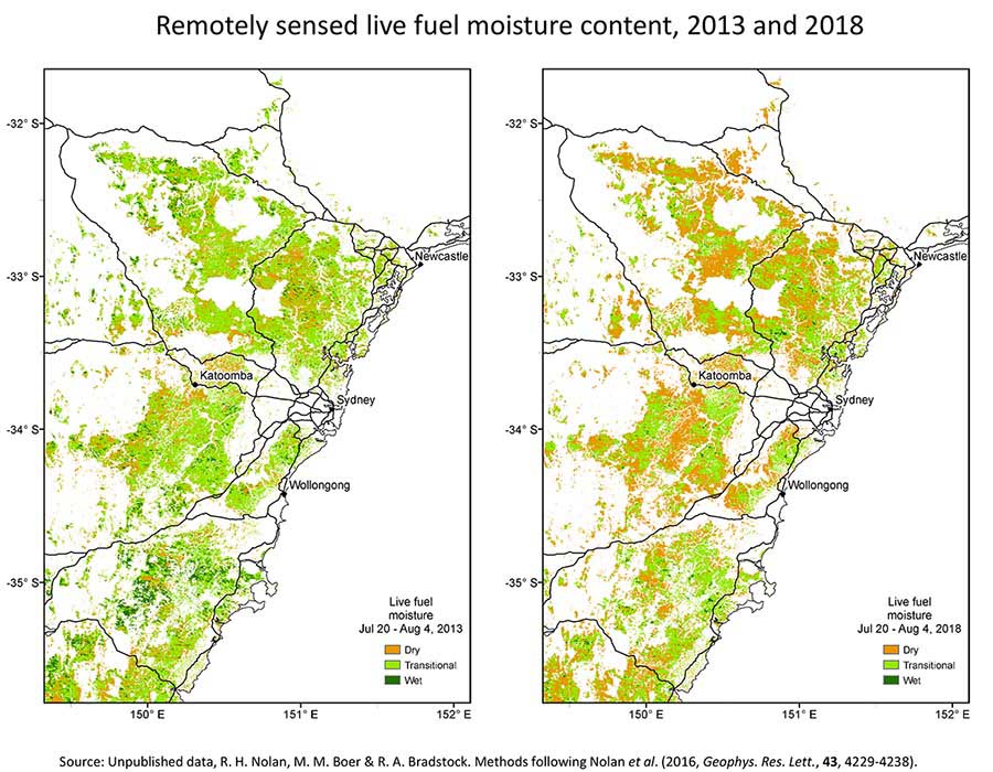 Maps comparing live fuel moisture levels in forests and woodland in the Sydney Basin in 2013, when the region suffered major bushfires, and this year.
Historically, when live fuel moisture content levels fall below 101.5 per cent it corresponds to a big increase in fire activity. Live fuel moisture levels are a better indicator of bushfire danger than the dead fuel moisture levels, which change more quickly in response to weather conditions.
Median live fuel moisture content levels across the Sydney Basin are now below the 101.5 per cent level and at a similar level to what they were when the October 2013 bushfires started.
Unless there is significant rainfall, the situation is likely to become worse as we move into spring and the weather warms up. The latest climate outlook from the Bureau of Meteorology suggest this is unlikely to occur.
“It is significant that the drying we have seen has occurred over winter when things dry out slowly. When temperatures increase, that drying will speed up,” Dr Price said.
Large, high-intensity bushfires occur when there are large continuous areas of vegetation dry enough to burn and weather conditions conducive to the rapid spread of fire (high temperatures, strong wind, low humidity), as well as an ignition event to start the fire.
The method of monitoring fuel moisture content developed by the team involves a combination of remote sensing and testing the method in the field. It picks up the rate at which live plants are drying out, as well as the moisture levels of dead material, such as leaves and branches on the forest floor. It can even predict fuel dryness across the course of a day as atmospheric humidity changes.
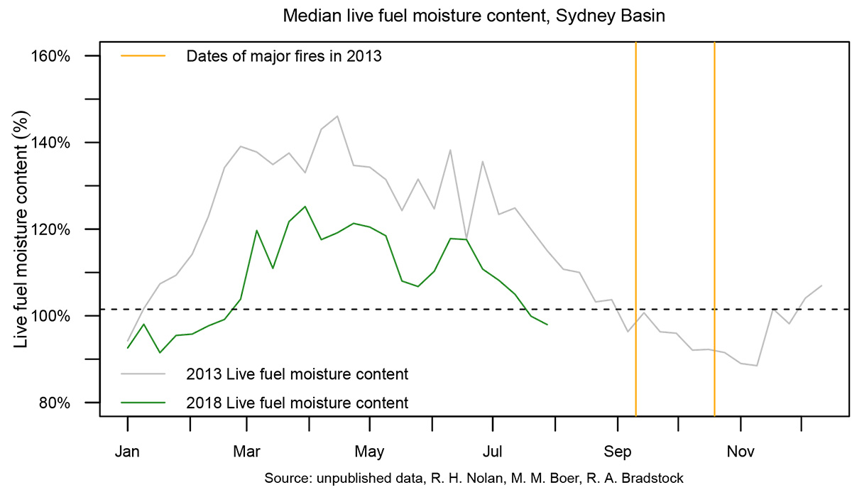 Median live fuel moisture content in the Sydney Basin in 2013 and 2018.
Dr Price said the research team used satellite imagery to monitor moisture levels in vegetation across large areas.
“These maps were made using MODIS (Moderate Resolution Imaging Spectroradiometer) satellite imagery, which shows reflections in the light spectrum. Moist leaves reflect red, green and blue light to different degrees; as the vegetation dries out, that spectral signature changes. “It gives us a very clear signal of the percentage of moisture in the leaves.”
While the current live fuel moisture content levels reflect the ongoing drought across NSW, long-term indicators suggest that the bushfire season is getting longer.
“With climate change, we are seeing the bushfire season arriving earlier and staying later,” Dr Price said.
“This has become really stark in the western United States where fire managers are saying that their wildfire season is all year long now.
“That change is happening more slowly here, but we’re heading in the same direction. This year, there was only a three month respite from the fire season, about half of what we normally expect.”